Feeling stuck in a rut at home? Get outside, get moving, and put some mileage between you and your blahs.
Whether you prefer to hike or paddle, Greater Parkersburg has lots of routes worth exploring. Even better, there’s something for everyone: No matter your interests, motivation, or level of fitness, there’s a trail or waterway that’s just right for you.
Count on nature to deliver unexpected entertainment along the way, from wildlife encounters to spectacular sunsets, seasonal blooms to rock formations, and plenty of other natural surprises. “That’s the wonderful thing about exploring the outdoors,” says Mark Lewis, an avid hiker and paddler who is also the President/CEO of Visit Greater Parkersburg. “There are so many little moments you get surprised and see something that’s totally unexpected.”
Come discover what nature has in store for you at any of Greater Parkersburg’s top outdoor destinations.
Take a Hike
Lace up your hiking shoes and hit the trail. Take your pick! In Greater Parkersburg all the trails are happy ones.
Blennerhassett Island Historical State Park, at 500 acres the fifth-largest island on the Ohio River, is a tranquil, enchanting haven with 6.5 miles of nature trails. Stroll past Harman and Margaret Blennerhassett’s reconstructed Palladian mansion, picnic under black walnut trees, or join available tours and wagon rides. The park is open from May through October; reach it by riding the Island Belle sternwheeler riverboat that departs from Point Park, a 2.8-acre park with its own walking/biking trail.
Fort Boreman Historical Park overlooks the Ohio and Little Kanawha Rivers at the former site of a Civil War fort. This 12-acre park offers spectacular views of the rivers’ confluence as well as the city of Parkersburg. A 400-foot long boardwalk trail is accessible for individuals with disabilities. Two additional short trails lead to the remains of the fort. While picturesque views are common here throughout the day, sunset can be particularly spectacular.
McDonough Wildlife Refuge is a 277-acre wildlife area with hiking trails that range from a half-mile to two miles. While hiking the well-marked trails that Lewis says are “mostly easy to moderate,” keep watch for animals including turkey, waterfowl, white-tailed deer, red and gray fox, and coyote.
Mountwood Park offers a network of trails for running, hiking, biking, and horseback riding throughout its 2,000 acres. Of the 40 miles of trails available for hiking, “most is single-track,” says Lewis, who has hiked more than 30 of those miles. “Some is fairly easy and some has significant elevation gain and loss, so you have a lot of varied terrain from which to choose an experience based on how hard you want work and how much you want to go up and down. There’s a lot of variety, everything from a 1.5-mile loop up to a grand tour that’s close to 10 miles. It’s really wonderful! One day within 100 yards on a trail I saw eight scarlet tanagers—I was absolutely there on the right day at the right time.”
North Bend Rail Trail is a 72-mile segment of the 5,500-mile American Discovery Trail (the nation’s first coast-to-coast, non-motorized trail). “It’s really easy hiking because it’s an old rail bed—once a main line of the CSX Railroad,” says Lewis. Nearly flat with a crushed limestone surface, the trail is ideal for leisurely walks or long bike rides. The trail corridor includes 35 bridges and 13 tunnels, at least one of which is rumored to be haunted. “Hiking through the Silver Run Tunnel is fun,” says Lewis. “The floors are very flat and even, not difficult at all, and it’s fairly long. When you get to the middle it’s kind of dark and then the light picks up again as you come to the other side. After a rain when water is draining off the hills the tunnel gets little puddles that fill with frogs and salamanders. Once a little baby fawn came out of the woods and straight at me, it was just born and still wobbly.” The rail trail can be accessed from many different points.
North Bend State Park boasts 2,400 acres of diverse offerings including 26 miles of trails on 14 different routes that vary in length and difficulty. The easiest trail is the paved and level “Extra Mile” trail, but you can choose a more challenging route. Expect natural surprises. “I found a miniature baby box turtle while hiking this park earlier this year,” says Lewis. At sunset, you may want to wander near the lake for amazing views.
Broughton Nature Preserve offers 800 acres of natural habitat for recreation. Among the options is the Devola multi-use trail, a part of the Marietta Ohio Trail System, that was completed in 2018. The 10-foot wide path includes two wide bridges is available for walkers, runners, cyclists, and strollers.
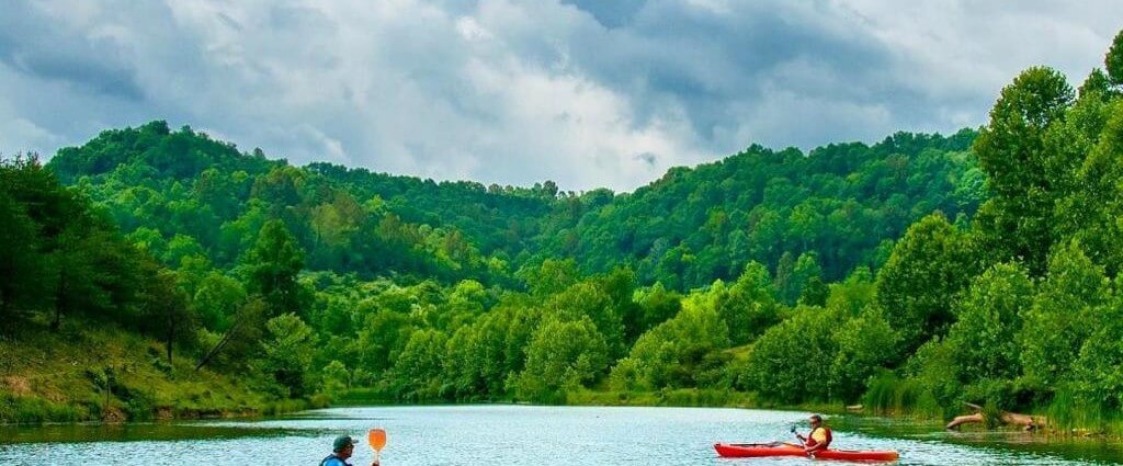
Grab a Paddle
Whether you bring your own boat or rent a kayak or canoe from Marietta Adventure Company or North Bend Outfitters, any day spent out on Greater Parkersburg’s waterways is a good one. Shuttles are not available during the 2020 season, but you can park one car at your destination before driving another vehicle to your put-in spot; or plan an out-and-back trip.
North Bend State Park is home to the nation’s largest colony of red-headed woodpeckers. Get an up-close look at these beauties as they flutter, nest, and tap wood while navigating the smooth, 305-acre lake. As you weave between the trees and stumps that rise out of the water, you might also spot blue-tinted tree swallows, northern flickers, eastern kingbirds, wood ducks, blue and green herons, and great crested flycatchers. Prefer fishing to birdwatching? Paddle the Hughes River for a chance to reel in bass, crappie, muskie, and catfish.
The Ohio River Watertrail encompasses 39 miles of the Ohio River and 18 miles of the Little Kanawha River. “I enjoy kayaking the Ohio River, there are some islands you can paddle around,” says Taylor. “Some people are afraid because the Ohio River does have more boat traffic, including barges, but as long as you keep an eye out and keep close to shore it’s not a big issue.” Since many of the islands are protected as part of the Ohio River Islands National Wildlife Refuge, there’s a good chance you’ll spot some wildlife. Put in at the Refuge Wildlife Center in Williamstown for a pretty, 3-mile paddle.
Duck Creek offers peaceful, still waters. “It’s scenic!” says Hallie Taylor, owner/manager of Marietta Adventure Company. One highlight among the photogenic sights is the Pratt Truss Bridge, invented in 1844 and one of the oldest known bridges of the modern era. Whether you’re up for a 14-mile or shorter paddle, put in at the Williamson Boat Ramp.
The French Creek Water Trail is a calm backwater paddle that starts north of Belmont near where the French Creek enters the Ohio River. The 2-mile trail slips through backwater where waterfowl are common sights before entering a narrow stream channel and then heading upstream to Henry Camp Run.
The Middle Island Creek Water Trail is another backwater paddle. Starting at St. Marys Marina, it heads to the mouth of Middle Island Creek then continues upstream to McKim Creek Bridge. This slow-paced paddle on easy flat water is a chance to immerse in nature’s beauty.
The Little Muskingum River northeast of Marietta parallels the Covered Bridge Scenic Byway for most of its length as it weaves through forested hills and pastures. Expect overhanging trees, abundant wildlife, and the chance to paddle under covered bridges that have crossed the river for more than a century. Paddle when water levels are up, unless you love to portage. “You do need sufficient water levels,” says Taylor. “Most of the put-ins are such that you’ll need to paddle ten miles or longer. The water has little ripples and trees can be down so you never know what you’ll have to work around, but it’s really beautiful.”
The Muskingum River, which at 112-miles ranks as Ohio’s longest navigable river, is the last river in the U.S. with hand-operated locks. One 2.5-mile route great for beginner paddlers starts at the Indian Acres boat ramp and ends at the Williamstown boat ramp. Some folks put in at the Indian Acres boat ramp for an out-and-back paddle. A 6-mile trip starts at Devol’s Dam and ends at the Williamson boat ramp. A 13-mile paddle from Lowell to Marietta goes through a historic hand-operated lock. “The lock is about five miles up from Marietta,” says Taylor. “Experience what was considered an engineering marvel of its time.” Depending on water levels, you may be able to put in closer to the dam for a shorter paddle.
The Ohio River Wildlife Refuge Water Trail is a 6-mile loop that starts at St. Marys Marina then circles nearby Middle Island, which at 235 acres is the largest of 22 islands protected by the Ohio River Islands National Wildlife Refuge. “It’s common to see wildlife in the shallow backwaters around St. Marys,” says Taylor. “It’s very marshy so gets cattails and other kinds of marsh grasses and flowers. It’s an area with tree stumps and a lot of fish habitat, so it’s a little bit challenging and pretty.”
Point Park on the waterfront in downtown Parkersburg is where to put in if you’d like to paddle over to Blennerhassett Island Historical State Park. Taylor recommends taking time to explore the island, even touring the mansion when possible.
Veto Lake is a picturesque 160-acre body of blue water with six miles of shoreline. “It has lots of little fingers to explore,” says Taylor. “Depending on the time of your visit, you might see lily pads blooming, trees in fall colors. It’s a nice, fun day paddle where it would be hard to get lost.” A parking lot and boat ramp are located near Marietta on the Ohio side of the Ohio River.
 Group Tour Information