
Wood County, WV
The history of the Greater Parkersburg area is as rich and varied as that of any part of the United States.
It stretches back to almost 9,000 BC when its first human inhabitants, Indians, are known to have lived, worked and played here. By the late 1600s, French explorers and traders had penetrated the region, soon followed by the English. But white settlement did not come until the 1760s when squatters illegally took possession of the Indians’ land. The United States Army drove the Indians out in 1785, the same year permanent settlers arrived.
What they found was a fertile valley covered by a dark, lush, jungle-like perfumed forest of monstrous trees filled with wild animals including buffalo and multi-colored parrots. Through the valley flowed the Ohio River, a great liquid highway that carried a vast and varied panorama of thousands of travelers into the heart of North America. In summer the river often dried to the size of a creek becoming a series of riffles and pools formed by innumerable sand and gravel bars. In many places the river was shallow enough to be walked across. At other times it became a raging torrent that quickly overflowed its banks.
After surviving a bloody Indian War (1791-1795), the area entered an era of gradual expansion and development. Population growth was very slow, however, and life very Southern in its customs. Many local settlers, originally from eastern Virginia, owned slaves and used them to carve out plantations. Barbecues and horse races helped pass the time in the people’s sleepy existence that was isolated to the extreme.
In 1811 the outside world started to break in when the Ohio River’s first steamboat went down the river and stopped at Parkersburg to refuel. The Northwestern Turnpike, connecting Winchester, Virginia and Parkersburg (paralleling present-day US Route 50), was completed in 1838. Nine years later, the Staunton-Parkersburg Turnpike (following modern-day WV Route 47) was finished. But Parkersburg’s greatest economic and population expansion came only after the railroad embraced it in her steel web. A branch of the Baltimore and Ohio Railroad reached Parkersburg in 1857, for the first time giving the town easy access to the East Coast and Cincinnati.
What would soon become one of the largest producing oil fields in the world was discovered in 1860 at Burning Springs, 40 miles up the Little Kanawha River. Parkersburg became the refining and shipping point for what seemed like an ocean of oil and communities with names like Volcano and Petroleum sprung up almost overnight with those hoping to make their fortune or just a living. Just like the oil itself, money flowed freely, and the area experienced an era of great wealth and prosperity.

The Civil War provided another vital impetus to the town’s growth. Because of its strategic geographical location on the B & O Railroad (exactly half way between Baltimore and St. Louis), Parkersburg became a major troop transfer and supply center for the Union Army. Following the Civil War, the area kept hold on its economic luck when, in the 1880s, deep depth drilling produced another oil boom almost simultaneously accompanied by a gas well boom. These brought a new wave of prosperity for the entire region, aiding the growth of local industry and ushering in the modern era.
Today the Greater Parkersburg area has a diversified economy. High tech producers including chemicals, plastics and laboratory equipment balance its conventional manufacturers such as glass and ferrous metals and recent additions such as mail order distribution and vehicle assembly. In a little over two hundred years, the area has grown from being an outpost on the edge of civilization to its own prominent role in the heartland of industrialized America.
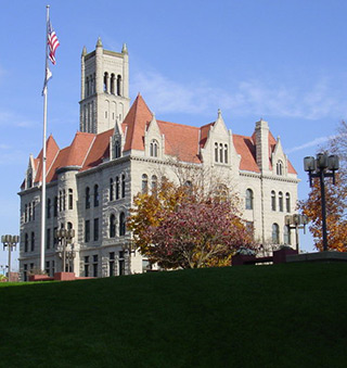
Organized on August 12, 1799 at the home of Hugh Phelps on the south side of the Little Kanawha River near Neal’s Station, after the Virginia legislature had refused several previous petitions, Wood County was named in honor of Virginia’s tenth governor, James Wood (1741-1813) who held office from 1796 to 1799. Formation of the new county immediately unleashed a bitter controversy for the control of political power. This struggle centered on the location of the county seat: Newport (soon to be renamed Parkersburg), Vienna, Williamstown and Monroe (located where the present day East Street bridge reaches south Parkersburg) all wanted it. Newport finally won the fray when the court accepted John Stokely’s offer of two acres near The Point on the north side of the Little Kanawha River. A two-story, hewn-log courthouse was built at the corner of what is now First and Juliana Street where the county’s business could be transacted.
Encompassing a gigantic 1,233 square miles when created, Wood County eventually began to shrink as newer counties were formed either wholly or partially from it. These included Jackson (1831), Ritchie (1843), Wirt (1848) and Pleasants (1851). Through the creation of these four, Wood County lost more than 70% of its original size and was reduced to its present-day 377 square miles
 Group Tour Information